The Aravalli vanishing mountain range, one of the oldest mountain systems in the world, is quietly disappearing in plain sight. Unlike the towering Himalayas, these hills rise gently from the land, often appearing as low, scrub-covered ridges that many mistake for wasteland. New 3D mapping and satellite analysis, however, reveal a far more complex and fragile landscape—one increasingly threatened by mining, construction, and policy ambiguity.

Stretching over 670 kilometres, the Aravallis run from Delhi’s rocky ridge through Haryana and Rajasthan before tapering off in Gujarat. They climb gradually towards the south-west, reaching their highest point at Mount Abu at around 1,700 metres. Yet much of the range consists of modest elevations between 300 and 900 metres, making them easy to overlook and, alarmingly, easy to erase.
A Mountain Range Hidden in 2Plain Sight:Aravalli vanishing mountain range
Most publicly available maps fail to capture the true extent of the Aravalli range. They often miss subtle changes in elevation and, more critically, the transformations unfolding on the ground. India Today’s Open Source Intelligence (OSINT) investigation used immersive 3D data, satellite imagery, and spatial analysis to uncover the scale of ecological loss across the range.
यह भी पढ़े:
 Osman Hadi Killers Fled to India via Meghalaya Border: Dhaka Police Reveal Shocking Escape Route
Unlike dramatic alpine landscapes, the Aravallis are defined by low ridges—many no taller than Delhi’s Qutub Minar. This understated geography has become a vulnerability. A growing confusion over what qualifies as an “Aravalli hill” has left many ecologically vital formations outside the ambit of legal protection.
Environmentalists warn that scrub-covered hills, though visually unimpressive, play a crucial role in groundwater recharge, biodiversity conservation, and climate regulation. When these hills vanish, the ecological consequences ripple far beyond their immediate surroundings.
The 100-Metre Definition and Its Consequences
At the heart of the controversy is a revised definition of what constitutes an Aravalli hill. Under the new criteria, accepted by the court following government recommendations, an Aravalli hill is defined as any landform rising at least 100 metres (328 feet) above the surrounding terrain or local relief.
यह भी पढ़े:
 Bulldozer Raj Karnataka Demolitions: Congress Govt Faces Backlash After 400 Muslims Left Homeless
Additionally, two or more such hills located within 500 metres of each other, along with the land between them, are collectively considered part of the Aravalli range. The government has argued that this definition brings clarity, reduces ambiguity, and ensures uniform regulation of mining across states.
Critics, however, argue that a uniform 100-metre cutoff threatens to exclude large portions of the range. Many Aravalli hills fall just short of this threshold but remain ecologically critical. Once excluded, these landscapes become vulnerable to mining, deforestation, and urban expansion.
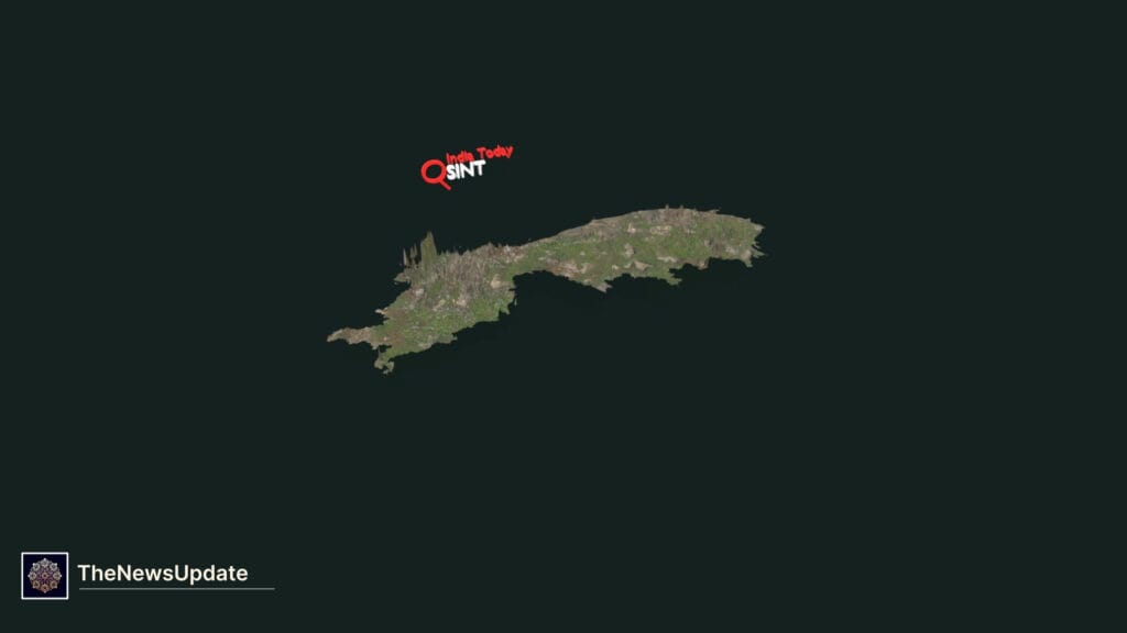
Mapping the Aravallis in 3D
To better understand the scale of the crisis, India Today’s OSINT team used high-resolution elevation data from the University of California’s OpenTopography research centre. The analysis mapped the Aravalli range from Mount Abu to New Delhi across its entire 670-kilometre span.

The data confirms that while the range does reach peaks above 1,700 metres, most of its terrain lies well below that mark. The majority of the Aravallis exist as gently undulating hills, ridges, and plateaus—precisely the forms most at risk under the revised definition.
The range begins as the Delhi Ridge and passes through large parts of Haryana, including Gurugram, Faridabad, Nuh (Mewat), Rewari, and Mahendragarh. It then stretches across Rajasthan, covering districts such as Sirohi, Udaipur, Rajsamand, Bhilwara, Ajmer, Tonk, Jaipur, Alwar, Dausa, Sikar, and Jhunjhunu, before extending into Gujarat.
Urban Expansion and Shrinking Green Cover
To assess how the Aravalli landscape has changed over time, India Today analysed land-use maps across Delhi, Haryana, and Rajasthan. Using data from Sentinel-2 satellites, researchers generated detailed land use land cover (LULC) maps to classify areas into urban zones, vegetation, and water bodies.

The findings are stark. Built-up areas across districts where the Aravallis lie expanded by more than 1,600 square kilometres over the past eight years. At the same time, vegetation cover declined sharply, shrinking from approximately 11,392 square kilometres to just 7,521 square kilometres.
This represents a loss of nearly one-third of green cover in less than a decade. The analysis focused on satellite imagery from the summer months between 2017 and 2025 to minimise cloud interference and ensure consistent optical data.
As cities expand and infrastructure projects multiply, the Aravallis are increasingly treated as expendable land, rather than as a critical ecological buffer.
यह भी पढ़े:
 Canada Hospital Killed Indian-Origin Man: Wife Alleges Medical Negligence After 8-Hour Wait
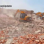
Mining Scars on an Ancient Landscape
Human interference is perhaps most visible in areas where mining has transformed the terrain beyond recognition. Satellite imagery examined by India Today reveals multiple sites where hills have been flattened or hollowed out entirely.
One such location is Bakrija Hill in Haryana. Once a low but distinct hillock, it now bears deep scars from extensive mining operations. Large sections of the hill have been carved away, leaving behind exposed rock faces and altered drainage patterns.
Another alarming example comes from the Ramalwas hills. A study published in the Indian Journal of Applied Research identified mining as a significant factor contributing to declining groundwater levels in the region. Villagers reported that mining pits had been dug beyond permissible depths, some reaching as deep as 200 feet.

Satellite images show open pits with visible groundwater exposure. In several cases, water-filled pits were left uncovered after stone extraction ceased, posing serious safety and environmental risks.
Deforestation and Fragmentation
Near Rajawas village in southwest Haryana, India Today identified a smaller ridge where one flank of the hilltop has been stripped bare. Deforestation combined with mining activity has left the landscape fragmented and vulnerable to erosion.
Such sites are not isolated. They are part of a broader pattern of degradation documented by researchers, activists, and local communities. Each flattened ridge weakens the ecological continuity of the Aravallis, making it harder for the ecosystem to recover.

Environmental experts warn that these disruptions also threaten wildlife corridors and reduce the region’s capacity to act as a barrier against desertification.
Scientific Warnings from Long-Term Studies
Concerns about the Aravallis are not new. A study by professors at the Central University of Rajasthan examined land-use dynamics across the range over several decades. Their findings paint a troubling picture of sustained ecological decline driven by mining, urbanisation, and deforestation.
Using satellite imagery and land-use maps from 1975 to 2019, the researchers estimated that nearly 5,772.7 square kilometres—about eight per cent of the total Aravalli region—had been flattened over a 44-year period.

The study, titled Assessment of Land-Use Dynamics of the Aravalli Range and published in the journal Science Earth Informatics in 2023, also issued a stark warning. As more hills disappear, the Thar Desert could expand eastward, inching closer to the National Capital Region.
Projections in the report suggest that by 2059, the Aravallis could lose as much as 16,360 square kilometres—nearly 22 per cent of their total area—if current trends continue.
Why the Aravallis Matter
Often dismissed as barren or unremarkable, the Aravallis play a vital ecological role. They act as a natural barrier against desertification, help recharge groundwater aquifers, and support diverse plant and animal life adapted to semi-arid conditions.

For cities like Delhi, the range serves as a critical green buffer, moderating temperatures and improving air quality. Its loss would not only reshape the physical landscape but also intensify environmental challenges in already stressed urban regions.
Experts argue that protecting only the tallest hills misses the point. The ecological value of the Aravallis lies in their continuity, not just their height.
Conclusion: A Race Against Time
The 3D maps and satellite data reveal an uncomfortable truth: the Aravalli range is vanishing, not through dramatic collapse, but through gradual erosion and neglect. Policy definitions, mining approvals, and unchecked urban growth are collectively reshaping one of the world’s oldest mountain systems.

As debates continue over definitions and regulations, the landscape itself continues to change—often irreversibly. Environmentalists warn that without a more nuanced and inclusive approach to protection, large swathes of the Aravallis could disappear before they are ever properly recognised.
The Aravallis you’ve never seen may soon be the Aravallis that no longer exist.
Related Reads
By The News Update — Updated December 23, 2025