Background of Cyclone Ditwah
Cyclone Ditwah Impact, which formed over the southwest Bay of Bengal, has captured widespread attention due to its potential threat to the eastern coast of India. Named by Yemen, “Ditwah” refers to a lagoon, inspired by the Detwah Lagoon in Socotra. As tropical cyclones in the Bay of Bengal often pose significant risks to coastal areas, authorities have closely monitored the system, issuing alerts and advisories for residents and travelers.
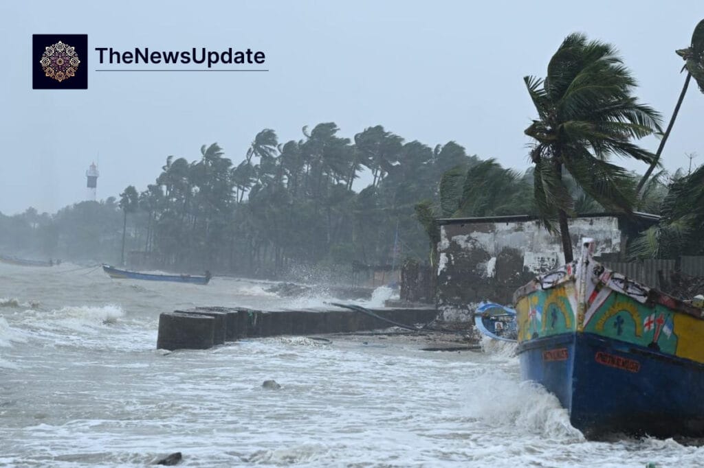
The storm gained intensity in the open waters and initially raised concerns for a possible landfall across the north coastal regions of Tamil Nadu and Puducherry. High waves were observed at Chennai’s Marina Beach, and heavy rains caused flooding in low-lying areas such as Rameswaram and Nagapattinam. Early reports indicated that strong surface winds of 60 to 70 kmph, with gusts reaching 80 kmph, were already impacting parts of the region.

Latest Update & Forecast
According to the India Meteorological Department (IMD), Cyclone Ditwah is now expected to avoid making direct landfall. The storm is projected to move northwards along the Tamil Nadu-Puducherry coastline while remaining over the southwest Bay of Bengal. By noon on November 30, the system is expected to be approximately 70 km away from the coast, decreasing to 30 km in the evening.
यह भी पढ़े:
 Osman Hadi Killers Fled to India via Meghalaya Border: Dhaka Police Reveal Shocking Escape Route
Weather experts suggest that Cyclone Ditwah is likely to weaken into a deep depression before gradually dissipating without touching land directly. This forecast has provided a cautious relief to residents and authorities, though the risk of high seas and heavy rainfall persists for at least the next 24 hours.
- Storm movement: Northwards along the coast
- Closest approach: 30–70 km from the coast
- Wind speeds: 60–70 kmph with gusts up to 80 kmph
- Expected system change: Cyclone → Deep Depression → Depression
Regional Impact on Tamil Nadu & Puducherry
Despite avoiding landfall, Cyclone Ditwah has already caused notable disruptions in the coastal districts. Flooding has been reported in Rameswaram, Nagapattinam, and low-lying areas in Ramanathapuram. Torrential rains continue over the Cauvery delta and districts including Cuddalore, Mayiladuthurai, Villupuram, Chengalpattu, Pudukkottai, Thanjavur, Thiruvarur, Ariyalur, Perambalur, Tiruchirappalli, Chennai, Kancheepuram, Tiruvallur, and Ranipet, as well as Puducherry and Karaikal.
The IMD forecasts heavy to very heavy rainfall in several districts and extremely heavy rainfall in isolated areas. Local residents have been advised to avoid coastal areas and exercise caution near rivers, canals, and other water bodies that may overflow during the storms. Fishing operations have been suspended, and authorities have issued warnings regarding high waves and rough sea conditions.
यह भी पढ़े:
 Bulldozer Raj Karnataka Demolitions: Congress Govt Faces Backlash After 400 Muslims Left Homeless
Government Response & Safety Measures
Tamil Nadu Revenue and Disaster Management Minister KKSSR Ramachandran confirmed that 28 disaster response teams, including SDRF and NDRF units, are on high alert. Additionally, 10 more teams are expected to arrive from neighboring states to ensure rapid response if the situation worsens. Evacuation plans for vulnerable areas are being prepared, though no mass evacuation has been ordered as the storm is not expected to make landfall.
Authorities have emphasized the importance of monitoring weather updates, keeping emergency supplies ready, and avoiding unnecessary travel. Communication networks in coastal towns are functioning, and residents are being informed of any changes in the cyclone’s trajectory through official channels.
Expert Analysis & Weather Commentary
Meteorologists and weather bloggers indicate that the storm’s weakening trend is a positive sign, but caution remains crucial. The proximity of Cyclone Ditwah to the coast can still generate strong surface winds, heavy rainfall, and localized flooding. Experts recommend that residents remain vigilant for at least another 24 hours as the cyclone slowly moves northwards over the Bay of Bengal.

From a climatological perspective, the Bay of Bengal frequently experiences cyclonic activity during November and December. While Cyclone Ditwah may not make landfall, its effects highlight the ongoing vulnerability of coastal regions to severe weather events. Preparing for high waves, storm surges, and heavy rains remains essential, even if the storm remains offshore.
Conclusion & What to Expect Next
Cyclone Ditwah Impact appears less severe than initially feared, as the system is likely to remain offshore and dissipate without making landfall. Nevertheless, residents of Tamil Nadu and Puducherry should remain alert, especially in low-lying areas and coastal towns. The next 24 hours will be critical for monitoring rainfall intensity, wind speeds, and sea conditions.
Authorities continue to coordinate with disaster response teams and local administrations to minimize risk. As the storm weakens into a depression, life-threatening conditions are expected to ease gradually by December 1, with rough seas turning less severe.

Related Reads
By The News Update Desk — Updated Nov 30, 2025